geodev-hackerlabs
Test your Python API installation
See the README for installation requirements and instructions.
The ArcGIS API for Python has a pythonic modular design. Whether talking to ArcGIS Online or ArcGIS Enterprise, your GIS is accessed using the argis.gis module. The GIS class provides the information model from which you access all the tools to visualize, analyze, manage, and administer your GIS.
Below we’ll use ArcGIS Online and access the module’s map widget to investigate the default behavior without signing in. Run the cell to bring up the default map.
Click the Open the Command Palette button on the Jupyter Notebook toolbar for instuctions on how to run a cell on the Operating System you use.
Set the map to a variable for access later in the notebook.
from arcgis.gis import GIS
my_gis = GIS()
map = my_gis.map()
map
Log properties from your map
Let’s investigate some default properties when using the map widget this way:
Object dot notation accesses properties and methods. Type the object’s name, followed by a dot, then the tab key to get a listing of all properties and methods on an object.
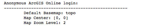
print("Anonymous ArcGIS Online login:")
print("{:-<50}".format(''))
print("\tDefault Basemap: {}".format(map.basemap))
print("\tMap Center: {}".format(map.center))
print("\tMap Zoom Level: {}".format(map.zoom))
Sign in and create a map
Sign in to https://www.arcgis.com or your own ArcGIS Enterprise to access your Map Viewer. An example is included to show formatting.
Use the getpass module to hide the password for your portal. Insert your own username and you’ll be prompted to enter your password after running the cell. Hit enter after you’ve typed your password.
import getpass
password = getpass.getpass("Enter password: ")
#p_gis = GIS(<YOUR PORTAL HOME URL>, <USERNAME>, password)
p_gis = GIS("https://www.arcgis.com", "[your username]", password)
# Entering a specific location and Zoom Level controls how the map draws
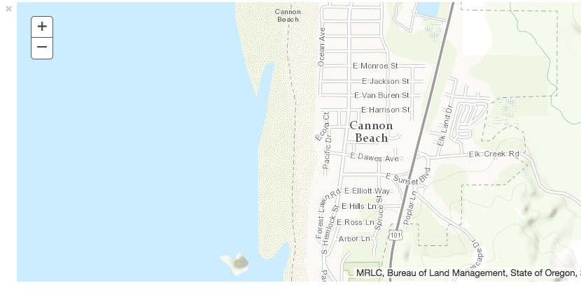
p_map = p_gis.map("Cannon Beach, OR", 12)
print("Successfully logged in as: " + p_gis.properties.user.username)
p_map
Update a few map properties
p_map.zoom = 15
p_map.height = '175px'
p_map.center = [45.89, -123.96]
# center needs to be a list of longitude, latitude coordinates
This exercise demonstrated how to login to ArcGIS Online (or ArcGIS Enterprise) and load a map with the ArcGIS API for Python. Subsequent labs will demonstrate additional functionality.
When you’re done, your notebook should look like create-map.ipynb.